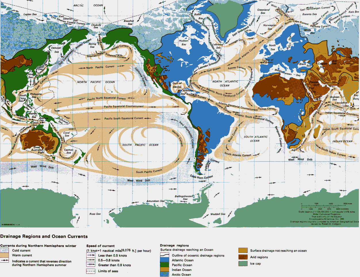
Labels:map | text | atlas OCR: ARCTIC OCEAN West Spitsbergen Greenland Current East Spitsbergen Current' Sea Kara Sea Laptev Sea Baffin East Siberian Coastal Current Fast Wftin Istand Current Barents Sea Siberian Bay Beaufort North Cape Current Yamal Current-4 Novaya Zemlya Current Chukchi Sea Norwegian Sea hora Current White AMMurman Current Bering CurrentT East Greenland Curren Norway Current Hudson Sea Bering Bay abrador Current & Labrador', Irminget Cub North Okhotsk Alaska Current Sea Saa Sea Aleutian Current Subarctic Current Current ( Anadyr Current" Bay of BIScay Ova C North Atlantic Current -> Azores Current k Sea +++ North Pacific Current California Current Labrador Extension Mediterranean Sea China the Gulf Stream Current NORTH PACIFIC OCEAN Gulf of Antilles Current NORTH ATLANTIC Atlantic North Equatorial Curren Persian Mexico OCEAN Isush Gloride Current anary Current Kuro Current Caribbean South Philippine DAbbeanzi wana Currently South Equatorial colon, Arabian China + Pacific North Equatorial Current Sea Benc Celabes Atlantic Equatorial Countercurrent: Laccadive Pacific Equatorial Countercurrent Monsoon Guinea Current Driftin Banda Indian Equatorial Counterel. See MAraTura Solomon Pacific South Equatorial Current - Sea » Ser East Australia peru (Humboldt)( East Africa Coastal Current Benguela Current /Seat Indian South" Equatorial Curre Mentor Current Coral SOUTH ATLANTIC Brazil Current OCEAN INDIAN OCEAN !! a Current 81 SOUTH PACIFIC OCEAN urrent - - West Australia Current Great -South Indian Current Australian Tasman Bight Ses Tasman South Atlantic Current "Agulha Current Current West: Wind Drift West Wind Drift South Pacific Current Cape Horn Current West Wind Drift Bellingshausen Amundsen Sea Sea 1000 3000 mules 1000 2000 3000 4000 kiommeters - Stale (approx ) 1.126.000.000 1 inch equals 1.975 miles Ross Sea Weddell Ses Miller Cylindrical Projection True scale only on the Equator Encyclopedia Britannica. Inc. 008 Drainage regions anginally compded by American Geographical Socie A-610000-9074 -1-5-1 revised by Robert D. Hodgson Drainage Regions and Ocean Currents Currents during Northern Hemisphere winter Speed of current Drainage regions Cold current (1 knot=1 nautical mile[6,076 ft.] per hour) Surface drainage reaching an Ocean Surface drainage not reaching an ocean Warm current 1 Less than 0.5 knots Outline of oceanic drainage regions Arid regions Indicates a current that reverses direction 0.5-0.8 knots Atlantic Ocean during Northern Hemisphere summer Greater than 0.8 knots Pacific Ocean Ice cap Limits of seas Indian Ocean Arctic Ocean